Detalles del producto
Medios


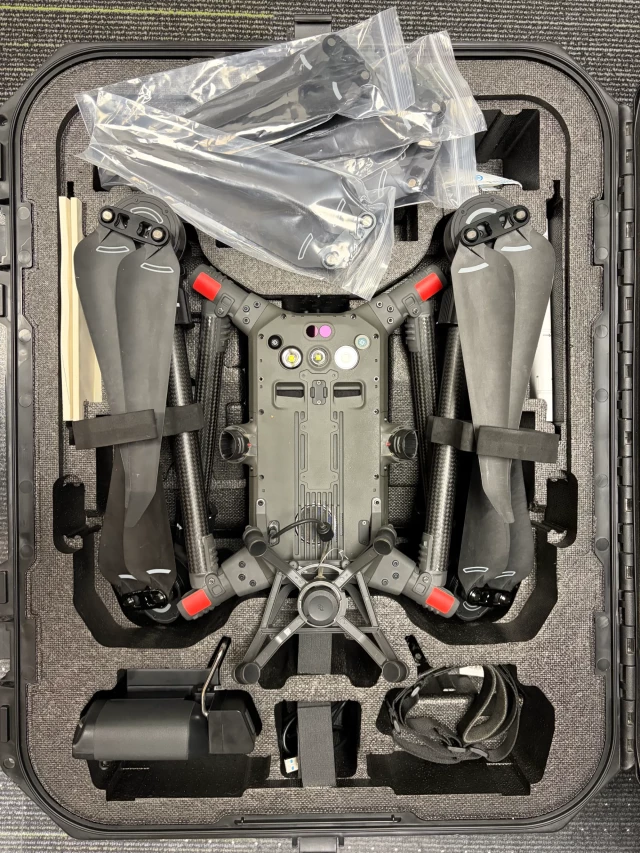
DJI Matrice 300 RTK Survey Bundle w/ D-RTK2 Base, SHARE 6100 SDK Camera & GS-130X LiDAR - Used
29,475 USD
Cantidad disponible
Una unidad disponible
Descripción
Complete turnkey survey drone bundle, combining three individually maintained units from the same professional survey operator into one platform + payload package: 1) DJI Matrice 300 RTK aircraft (S/N 1ZNBJ8700C01M2) with Enterprise Remote Controller (S/N 1ZMBJ7800303BU). Kit includes 8 TB60 batteries (1st version), 2 TB60 batteries (350 RTK version), smart charger/charging hub, D-RTK 2 Mobile Base Station, and 3 additional batteries for the base station/controller auxiliary battery. 2) SHARE 6100 SDK single-lens aerial mapping camera (S/N S6100K230616), compatible with DJI Matrice M300/M350 RTK platforms. Professional mapping lens for cadastral surveys and infrastructure inspection. 3) Geosun GS-130X airborne LiDAR system (S/N AGS323065109) fitted with the AGS303 positioning module (normally reserved for the higher-end GS-260X: Heading 0.017°, Pitch/Roll 0.005° angular accuracy). Dual-return, 60,000/1,200,000 pts/sec, built-in 26MP RGB camera, PPK-only operation, with gAirHawk processing software included. Together these give a turnkey survey-grade drone platform with interchangeable camera and LiDAR payloads for cadastral, mapping, and infrastructure inspection work. All items well maintained, from a professional survey operator. Located in Torres Vedras, Portugal. Photos available on request. Note: weight and dimensions listed are estimated for the combined kit and should be confirmed before publishing.
Fecha de validez de la garantía
Sin garantía
Política de devoluciones
Ver términos y condiciones para devolver su compra.
DJI Matrice 300 RTK Survey Bundle w/ D-RTK2 Base, SHARE 6100 SDK Camera & GS-130X LiDAR - Used
29,475 USD
Cantidad disponible
Una unidad disponible
Descripción
Complete turnkey survey drone bundle, combining three individually maintained units from the same professional survey operator into one platform + payload package: 1) DJI Matrice 300 RTK aircraft (S/N 1ZNBJ8700C01M2) with Enterprise Remote Controller (S/N 1ZMBJ7800303BU). Kit includes 8 TB60 batteries (1st version), 2 TB60 batteries (350 RTK version), smart charger/charging hub, D-RTK 2 Mobile Base Station, and 3 additional batteries for the base station/controller auxiliary battery. 2) SHARE 6100 SDK single-lens aerial mapping camera (S/N S6100K230616), compatible with DJI Matrice M300/M350 RTK platforms. Professional mapping lens for cadastral surveys and infrastructure inspection. 3) Geosun GS-130X airborne LiDAR system (S/N AGS323065109) fitted with the AGS303 positioning module (normally reserved for the higher-end GS-260X: Heading 0.017°, Pitch/Roll 0.005° angular accuracy). Dual-return, 60,000/1,200,000 pts/sec, built-in 26MP RGB camera, PPK-only operation, with gAirHawk processing software included. Together these give a turnkey survey-grade drone platform with interchangeable camera and LiDAR payloads for cadastral, mapping, and infrastructure inspection work. All items well maintained, from a professional survey operator. Located in Torres Vedras, Portugal. Photos available on request. Note: weight and dimensions listed are estimated for the combined kit and should be confirmed before publishing.
Fecha de validez de la garantía
Sin garantía
Política de devoluciones
Ver términos y condiciones para devolver su compra.
Equipo similar




Detalles del producto
Medios
DJI Matrice 300 RTK Survey Bundle w/ D-RTK2 Base, SHARE 6100 SDK Camera & GS-130X LiDAR - Used
29,475 USD
Cantidad disponible
Una unidad disponible
Descripción
Complete turnkey survey drone bundle, combining three individually maintained units from the same professional survey operator into one platform + payload package: 1) DJI Matrice 300 RTK aircraft (S/N 1ZNBJ8700C01M2) with Enterprise Remote Controller (S/N 1ZMBJ7800303BU). Kit includes 8 TB60 batteries (1st version), 2 TB60 batteries (350 RTK version), smart charger/charging hub, D-RTK 2 Mobile Base Station, and 3 additional batteries for the base station/controller auxiliary battery. 2) SHARE 6100 SDK single-lens aerial mapping camera (S/N S6100K230616), compatible with DJI Matrice M300/M350 RTK platforms. Professional mapping lens for cadastral surveys and infrastructure inspection. 3) Geosun GS-130X airborne LiDAR system (S/N AGS323065109) fitted with the AGS303 positioning module (normally reserved for the higher-end GS-260X: Heading 0.017°, Pitch/Roll 0.005° angular accuracy). Dual-return, 60,000/1,200,000 pts/sec, built-in 26MP RGB camera, PPK-only operation, with gAirHawk processing software included. Together these give a turnkey survey-grade drone platform with interchangeable camera and LiDAR payloads for cadastral, mapping, and infrastructure inspection work. All items well maintained, from a professional survey operator. Located in Torres Vedras, Portugal. Photos available on request. Note: weight and dimensions listed are estimated for the combined kit and should be confirmed before publishing.
Fecha de validez de la garantía
Sin garantía
Política de devoluciones
Ver términos y condiciones para devolver su compra.
DJI Matrice 300 RTK Survey Bundle w/ D-RTK2 Base, SHARE 6100 SDK Camera & GS-130X LiDAR - Used
29,475 USD
Cantidad disponible
Una unidad disponible
Descripción
Complete turnkey survey drone bundle, combining three individually maintained units from the same professional survey operator into one platform + payload package: 1) DJI Matrice 300 RTK aircraft (S/N 1ZNBJ8700C01M2) with Enterprise Remote Controller (S/N 1ZMBJ7800303BU). Kit includes 8 TB60 batteries (1st version), 2 TB60 batteries (350 RTK version), smart charger/charging hub, D-RTK 2 Mobile Base Station, and 3 additional batteries for the base station/controller auxiliary battery. 2) SHARE 6100 SDK single-lens aerial mapping camera (S/N S6100K230616), compatible with DJI Matrice M300/M350 RTK platforms. Professional mapping lens for cadastral surveys and infrastructure inspection. 3) Geosun GS-130X airborne LiDAR system (S/N AGS323065109) fitted with the AGS303 positioning module (normally reserved for the higher-end GS-260X: Heading 0.017°, Pitch/Roll 0.005° angular accuracy). Dual-return, 60,000/1,200,000 pts/sec, built-in 26MP RGB camera, PPK-only operation, with gAirHawk processing software included. Together these give a turnkey survey-grade drone platform with interchangeable camera and LiDAR payloads for cadastral, mapping, and infrastructure inspection work. All items well maintained, from a professional survey operator. Located in Torres Vedras, Portugal. Photos available on request. Note: weight and dimensions listed are estimated for the combined kit and should be confirmed before publishing.
Fecha de validez de la garantía
Sin garantía
Política de devoluciones
Ver términos y condiciones para devolver su compra.
Equipo similar